LOCUS-0
Spatial Intelligence at Your Fingertips
Accurately capturing and understanding a physical space often requires specialized hardware, trained operators, or carefully controlled, slow capture workflows. Yembo's mission is to change that.
Our goal is to make spatial understanding accessible through devices people already own and carry with them every day. We believe that a handheld phone capture – across a broad range of consumer devices – should be enough to create an accurate, structured, and measurable property representation.
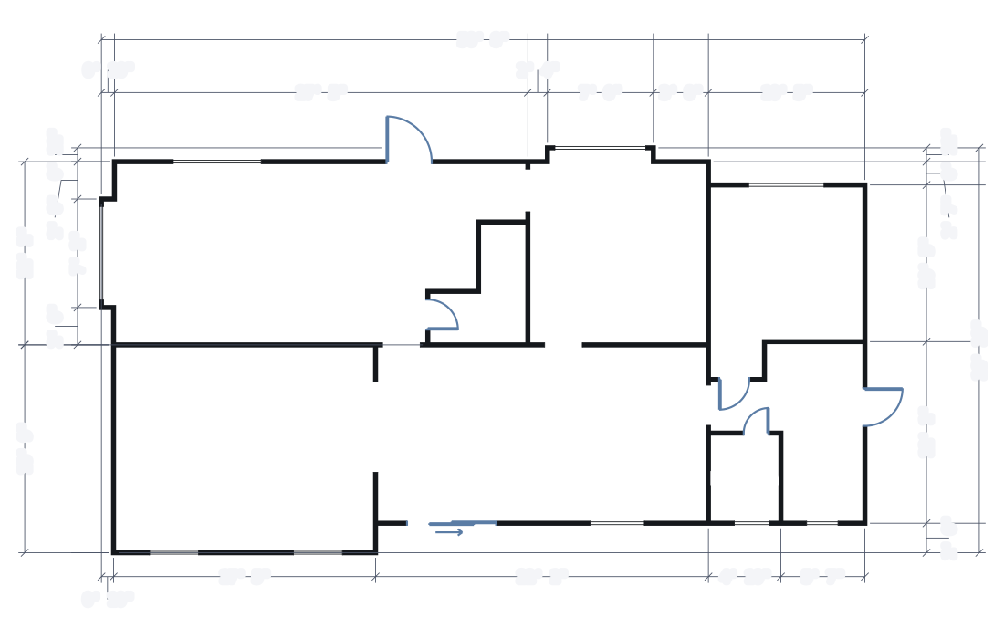
Today, we are introducing our first step toward this goal: LOCUS-0, Yembo's spatial intelligence model. It transforms ordinary handheld phone captures into accurate digital twins of real-world spaces. A useful spatial representation should not only provide measurable geometry but also describe the underlying structure of a space: its contents, floor plans, and wall elevations, along with the relationships among them.
LOCUS-0 outperforms all previously published AI models on 3D reconstruction tasks measured on a real-world dataset across multiple key metrics. While large generalist models dominate current industry focus, their performance per unit of compute – the metric that drives real-world adoption – is poor. LOCUS-0 is not just the absolute best model for 3D reconstruction; it's also the only model that we know of that works in near real time and fits within a 16 GB consumer GPU.
LOCUS-0 is in production today, powering our insurance claims and relocation workflows and processing 1,000 properties every day. As we continue to grow and improve LOCUS, it will provide the engine for future Yembo products.
From Pixels to Measurable Spaces
LOCUS-0 focuses on understanding scene contents. Its predictions form a metric representation of the physical space that can be inspected, measured, and reasoned about.
Below, you can explore the reconstructed geometry, take measurements, inspect semantic predictions, and see the LOCUS estimate of the underlying room structure.
LOCUS can provide rich per-frame information.
Beyond a Single Frame
Individual predictions can give us a good idea of what LOCUS can do, but for those predictions to be useful in downstream applications, we need to go beyond a single frame and assemble them into a global representation of an entire property.
The reconstructions below were built from handheld mobile captures – without a dedicated spatial-capture camera or specialized scanning rig.
Specialized capture systems have already demonstrated how useful a persistent, measurable digital representation of a property can be. Our goal is to make that capability broadly accessible without requiring dedicated capture hardware – using the phone people already have.
Architecture
LOCUS-0 is a feed-forward transformer network at the center of our reconstruction and scene-understanding systems. It is trained on a proprietary dataset of mobile captures of indoor spaces.
LOCUS supports reconstruction using only RGB video. However, it is designed from the ground up to take advantage of the additional signals available on modern mobile devices: camera intrinsics and poses from platforms such as ARKit and ARCore, and LiDAR depth when available. When additional camera parameters are provided, LOCUS treats them as estimates rather than ground truth, refining the camera trajectory and calibration as part of the reconstruction. This is particularly important for real-world mobile capture, where tracking can drift or occasionally produce unusable poses. We believe users should have access to high-quality results regardless of the device they own. While depth measurements can provide additional information, LiDAR-equipped hardware is not required.
From the available inputs, LOCUS jointly estimates the quantities needed to reconstruct and understand the captured space: camera poses and intrinsics, dense depth, semantic information, and the structural organization of the scene, including layout and elevation information.
The result is a single model capable of operating across a broad spectrum of devices – from RGB-only captures to devices providing richer geometric signals – while taking advantage of whatever information is available.
Built on Real-World Data
LOCUS-0 is trained on YemboScenes, our continuously growing dataset of real-world mobile captures. Today, YemboScenes contains nearly two orders of magnitude more frames than ScanNet[1], together with rich geometric and structural information including camera trajectories, LiDAR depth, and expert-annotated floor plans.
YemboScenes continues to grow through Yembo's production systems. Every day, new captures flow through our in-house data engine, where they are processed and transformed into training data for future generations of our models. This creates a continuous improvement loop: as the dataset grows, LOCUS will be exposed to more of the complexity found in real properties.
Scaling beyond the Context Window
Recent feed-forward reconstruction models[2][3][4][5] have demonstrated impressive results by jointly reasoning over many views. However, this approach presents a fundamental systems challenge: as the number of observations grows, so do the computational and memory requirements of the reconstruction system.
For real-world spatial capture, we don't think the size of the final reconstruction should be dictated by the context size of a transformer. To address this, LOCUS is designed as part of a modular reconstruction system. We combine strong learned geometric priors with robust online optimization, allowing each component to operate where it is strongest.
Rather than requiring an entire capture to fit within a single network context, LOCUS produces strong geometric estimates from small groups of observations. Our optimization system then integrates those estimates into a globally consistent reconstruction, decoupling the length of the capture from the context size of the underlying transformer. The resulting system can process long captures while operating within 16 GB of GPU memory.
Qualitative Results
The modular design of LOCUS allows us to process a much larger number of frames, but we need to ensure that the resulting reconstruction quality does not suffer.
The viewer below shows the same captures reconstructed by LOCUS-0 and state-of-the-art open reconstruction models, Pi3X[4] and MapAnything[5]. These systems also allow for camera pose input, providing a good basis for comparison. In practice, we have found that LOCUS is more robust to the camera pose errors we observe in real-world captures. For fairness, we limit this comparison to cases where the input trajectory was already of high quality.
Reconstructions from the same phone capture. Pick any two of the four layers. Drag the handle to compare; drag elsewhere to control the camera. In error mode, a reconstruction is colored by its distance to the ground-truth LiDAR surface.
Quantitative Results
Across metrics measuring reconstruction accuracy, metric scale, camera pose estimation, and global consistency, LOCUS compares favorably with leading open reconstruction models. However, reconstruction quality is just one axis of the comparison. A practical system also has to scale to the length of real captures.
Because LOCUS does not require every observation to occupy the same transformer context, its memory requirements remain practical even as captures grow. In contrast, models that jointly process large sets of views eventually become constrained by GPU memory. To illustrate this, we show results with a larger memory budget of 24 GB alongside results with the 16 GB available on our target deployment GPU.
Comparison details
All methods ran on the same 51 captures from our internal test set. Every prediction is aligned to the LiDAR ground truth.
Metric details:
- F-score[6] is the share of the surface within 4 cm of the ground-truth surface. The alignment for this metric is rigid (SE(3)).
- Relative F-score is the same metric, but the alignment solves for scale as well (Sim(3))[7], which separates shape quality from metric accuracy. For our applications, this metric is less useful, since we do not know the ground-truth scale at inference time.
- Scale error measures how far the scale factor between estimated geometry and ground truth is from 1. A scale factor of 1 indicates a perfect scale prediction. The error is defined as
|s - 1|, wheresis the scale factor found by aligning the prediction to the ground truth. - Trajectory error is the standard absolute trajectory error (ATE)[8].
Pi3X and MapAnything attend across every view at once, so their memory use grows with the number of frames. To fit within 24 GB, they were given a view budget: at most 128 views for Pi3X and 125 for MapAnything, chosen by reducing the frame sampling rate per scan. The 40-view toggle shows the same models with the 16 GB budget our deployment GPU provides. LOCUS-0 has no view budget; we use our production pipeline default, resulting in 193 views per scan on average and up to 413.
LOCUS-0 is a modular system, so a natural question arises: what would happen if we replaced our model with an off-the-shelf one like MapAnything or Pi3X? We ran both with the same view grouping and incremental optimizer, each taking its scale from the capture trajectory. Both improve on their standalone versions in absolute F-score, scale error, and trajectory error, with the surrounding system doing work the model no longer has to. What they lose is shape: relative F-score, which is what survives after the best scale is solved for, drops for both because these models were trained to operate with many views at the same time, while the pipeline runs them in a few-view regime. Neither configuration reaches LOCUS-0 on any of the four metrics. Although these models can produce impressive results in a single forward pass, they require data-center-grade GPUs to process the same view counts as LOCUS. We argue that this limits their deployability.
Edge Deployment
Although we can deploy our system on GPUs with relatively small amounts of RAM, we ultimately want spatial intelligence to live where the capture happens.
The full LOCUS-0 reconstruction system described above uses our production compute infrastructure. In parallel, we have been distilling the geometric knowledge learned by LOCUS into substantially smaller models designed for resource-constrained edge environments.
Our early mobile prototypes are a first look at a distilled LOCUS model. It can already operate as part of a mobile SLAM system, using learned geometric predictions to improve camera tracking directly during capture. We are actively working toward bringing increasingly capable pieces of the LOCUS stack onto both Android and iOS devices.
Spatial intelligence becomes much more broadly useful when capture can provide immediate feedback, when poor connectivity isn't a barrier, and when users can interact with the results directly on the devices in their hands.
Next Steps
LOCUS-0 already brings geometry, camera understanding, metric scale, semantics, and structural reasoning into a shared spatial model. Over the years, Yembo has built a large and diverse dataset of real-world indoor environments, including extensive object-level annotations collected through our production workflows.
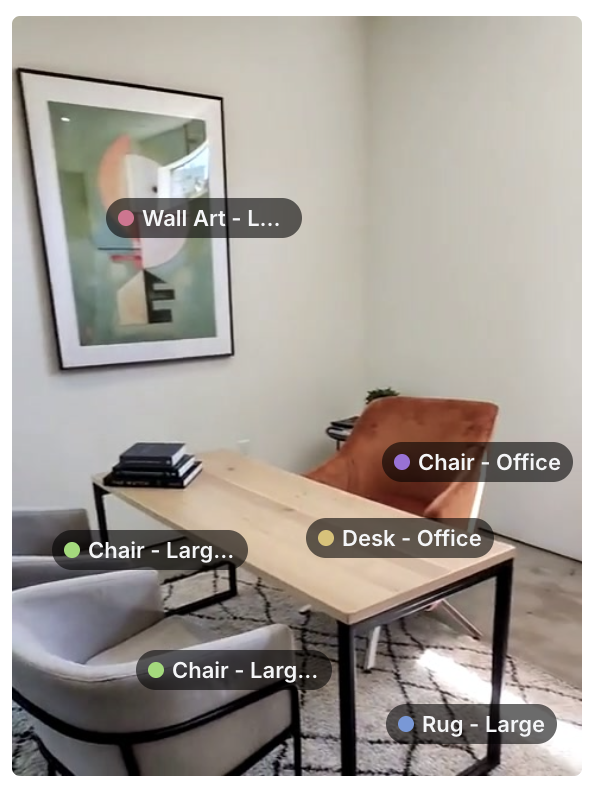
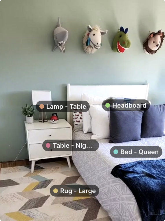
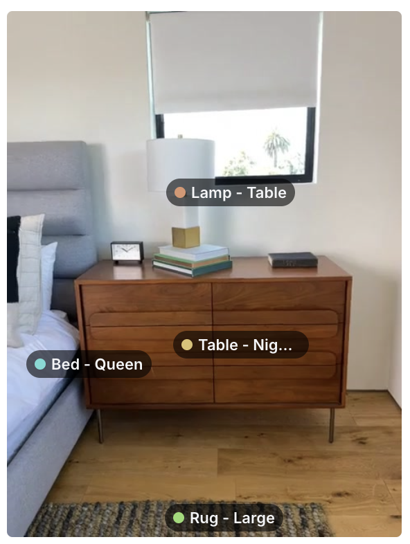
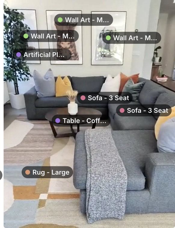
Future versions of LOCUS will extend the representation that currently reasons about geometry and structure toward a richer understanding of the objects that occupy a space – not only where things are, but what they are and how they relate to the environment around them.
LOCUS-0 is the first realization of our vision. With a continuously growing dataset of real-world mobile captures and a data engine designed to turn it into better models, we are pushing LOCUS toward two goals at once.
- We want it to understand more – moving beyond geometry and structure, and toward a richer semantic understanding of the objects and spaces around us.
- We want that understanding to require less – less specialized hardware and fewer constraints on how a space is captured – while ultimately producing our rich results directly on the device.
References
- A. Dai, A. X. Chang, M. Savva, M. Halber, T. Funkhouser and M. Nießner. ScanNet: Richly-annotated 3D Reconstructions of Indoor Scenes. CVPR 2017. arXiv:1702.04405 (opens in a new window), scan-net.org (opens in a new window).
- S. Wang, V. Leroy, Y. Cabon, B. Chidlovskii and J. Revaud. DUSt3R: Geometric 3D Vision Made Easy. CVPR 2024. arXiv:2312.14132 (opens in a new window).
- J. Wang, M. Chen, N. Karaev, A. Vedaldi, C. Rupprecht and D. Novotny. VGGT: Visual Geometry Grounded Transformer. CVPR 2025. arXiv:2503.11651 (opens in a new window).
- Y. Wang, J. Zhou, H. Zhu, W. Chang, Y. Zhou, Z. Li, J. Chen, J. Pang, C. Shen and T. He. π³: Permutation-Equivariant Visual Geometry Learning. ICLR 2026. arXiv:2507.13347 (opens in a new window). Pi3X is the authors' enhanced release of the model with optional pose, intrinsics and depth inputs: code (opens in a new window), weights (opens in a new window).
- N. Keetha, N. Müller, J. Schönberger, L. Porzi, Y. Zhang, T. Fischer, A. Knapitsch, D. Zauss, E. Weber, N. Antunes, J. Luiten, M. Lopez-Antequera, S. Rota Bulò, C. Richardt, D. Ramanan, S. Scherer and P. Kontschieder. MapAnything: Universal Feed-Forward Metric 3D Reconstruction. 3DV 2026. arXiv:2509.13414 (opens in a new window), code (opens in a new window).
- A. Knapitsch, J. Park, Q.-Y. Zhou and V. Koltun. Tanks and Temples: Benchmarking Large-Scale Scene Reconstruction. ACM Transactions on Graphics 36(4), 2017. tanksandtemples.org (opens in a new window).
- S. Umeyama. Least-Squares Estimation of Transformation Parameters Between Two Point Patterns. IEEE Transactions on Pattern Analysis and Machine Intelligence 13(4), 1991. doi:10.1109/34.88573 (opens in a new window).
- J. Sturm, N. Engelhard, F. Endres, W. Burgard and D. Cremers. A Benchmark for the Evaluation of RGB-D SLAM Systems. IROS 2012. doi:10.1109/IROS.2012.6385773 (opens in a new window).